A strengthening El Niño in the Pacific Ocean is shaping up to deliver a polarized winter across the country, with nine states projected to see above-average snowfall while others face unseasonably warm and dry conditions. The National Oceanic and Atmospheric Administration's (NOAA) Climate Prediction Center expects the weather phenomenon to range from strong to very strong through March 2027, significantly altering traditional winter patterns. Meteorologists note that the ongoing atmospheric shift will likely push the jet stream southward and eastward, increasing storm activity across the southern tier of the country.
Now is the time for communities and individuals to plan ahead for the upcoming winter.” Federal officials caution that heavy rainfall on parched terrain carries a heightened risk of flash floods and mudslides ahead of the official start of winter on December 21. El Niño is the warm phase of the El Niño-Southern Oscillation (ENSO) cycle. It occurs between every two to seven years and typically lasts between nine and 12 months, although a particularly strong El Niño can last longer.
It is characterized by unusually warm ocean temperatures in the equatorial Pacific and weakened trade winds, which can influence weather around the globe in different ways. This year's El Niño has already broken records in terms of how far above average the ocean surface temperatures have risen. A stronger El Niño can be associated with stronger storms.
La Niña is the opposite of El Niño. It is characterized by stronger trade winds and unusually cold ocean temperatures in the equatorial Pacific. In the United States, El Niño's influence is typically strongest during the fall and winter months.
Historically, stronger El Niño events have favored a more active storm track across the southern tier of the country while bringing warmer-than-average temperatures to parts of the northern U.S. As a result, some states that normally see significant winter snowfall can experience reduced totals when warmer air dominates. At the same time, the shift in storm patterns can boost snowfall in other regions by delivering both the moisture and cold air needed for snow, allowing some states that saw relatively little snowfall the previous winter to experience snowier-than-average conditions.
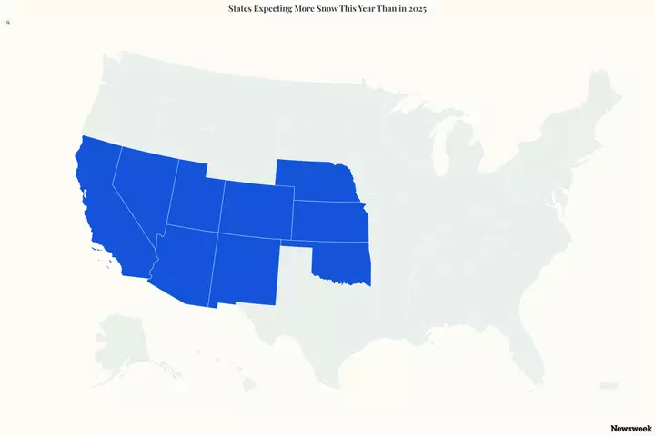
The states that could see more snow this winter are ones that didn't see much snow last winter, according to a report by AccuWeather published earlier this month. While the North, Midwest, and Northeast are expecting below-average snowfall this winter, the Intermountain West, Southwest, and Central U.S. could see above-average totals. When compared to last year, the states most likely to see more snow than they did in 2025 are Nebraska, Kansas, Oklahoma, Utah, Colorado, Arizona, New Mexico, Nevada, and California, AccuWeather senior meteorologist and long-range forecaster Chad Merrill told Newsweek on Monday, crediting "the strong footprint of El Niño" for the forecast.
Extract — continue reading at the source.