Capturing the fine details of behavior when animals perform complex tasks, such as prey pursuit and capture, in natural environments is a challenging endeavor. For birds of prey, commonly used tracking approaches, such as lightweight GPS and inertial measurement units, cannot simultaneously track the bird’s position and the fine details of body part motion or moving external objects. Here we designed a head-mounted, tetherless, 4π camera system which, combined with a high-resolution environmental scan, enabled detailed three-dimensional measurement of both head position and orientation in freely flying Harris’s hawks (Parabuteo unicinctus) performing aerial pursuit in the wild.
This stable head-mounted imaging approach enabled reconstruction of flight trajectories in natural environments, detailed quantification of head motion, optic flow and target position, while the bird tracked and captured airborne targets. Capturing animal behavior in natural environments1,2,3,4,5,6,7 is a challenging endeavor, particularly for quantifying fine kinematics or an animal’s interaction with complex environmental features8. Over the past decade a number of methods have been developed for high-resolution animal tracking allowing quantification of animal kinematics during free behavior9,10,11,12,13,14,15,16,17,18,19 as well as visual scene reconstruction20,21,22,23,24.
The majority of these approaches require a laboratory environment that allows utilization of synchronized high-speed, high-resolution camera arrays that are calibrated for reconstructing animal’s three-dimensional (3D) position and motion, which limits the environmental complexity and spatial dimensions that the animals interact with, leading to a simplification of the behavioral repertoire25,26,27. The large physical dimensions typical for natural environment home ranges make imaging-based tracking methods for 3D reconstruction of position19,22,23 impractical due to the requirements for overlapping camera fields of view. Another approach has been to use the global navigation satellite system (GNSS) by using animal-worn devices, which allow animal trajectories to be related to existing digitized topographical maps28,29,30,31,32,33,34,35,36,37,38.
A similar approach, at least for ground-based animals, has been to use drone-based photometry to generate high-resolution digital maps, in combination with animal-worn tracking devices for position39,40,41. However, these approaches are limited in spatial accuracy (in the range of meters) for smaller animals that have limited weight-bearing capacity. GNSS approaches, such as post-processing kinematics42,43,44,45 enable highly accurate spatial tracking but have the disadvantages that they do not measure head orientation, the high-gain antennas require environments without impaired GNSS reception and they are cumbersome for smaller or lighter animals.
These limitations place constraints on measuring an animal’s interaction with environmental features and objects such as prey items or conspecifics2. Animal-borne camera systems8 provide another possibility for tracking animals while also providing the opportunity for simultaneous monitoring of behavior. Here, we show accurate position and head orientation tracking in a freely flying Harris’s hawk (Parabuteo unicinctus) performing aerial pursuit in a natural environment achieved by combining high-resolution environmental scans with a custom-made head-mounted omnidirectional (4π steradians) camera system which provided a near complete surround view of the bird and its surrounding environment during the behavior.
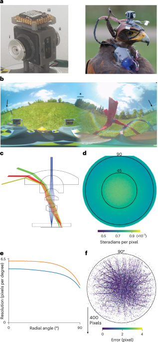
We designed the head-mounted imaging system to enable inference of position and head orientation of freely flying birds as well as simultaneously capturing environmental events, such as relative target positions and body feature dynamics during aerial target capture. We developed a custom lens-set combined with two image sensors (Fig. 1a) enabling the construction of a 6 g camera system with each lens having a 210° field of view restricted to 190° to 210° by the sensor, together enabling a full 360° surround coverage (Fig. 1b). The lens-set (Fig. 1c) was designed as equidistant to minimize the variation of pixel resolution over the field of view (Fig. 1d,e), resulting in low reprojection error across the whole field of view after calibration (Fig. 1f and Extended Data Fig. 1).
Extract — continue reading at the source.