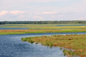
All the United States Maine Scarborough Scarborough Marsh Maine’s largest salt marsh hides old roads, drainage ditches, and the remains of a canal once cut through its grasses. Scarborough Marsh covers over 3,000 acres. AlanBuncher / CC BY-SA 4.0 A black-bellied plover in Scarborough Marsh.
Chuck Homler / FocusOnWildlife.Me A black-bellied plover in Scarborough Marsh. Chuck Homler / FocusOnWildlife.Me Scarborough Marsh covers over 3,000 acres. AlanBuncher / CC BY-SA 4.0 Scarborough Marsh covers over 3,000 acres.
Chuck Homler / FocusOnWildlife.Me Scarborough Marsh looks like a simple place ruled by tides and birds. But a deeper story lies just beneath the surface of the water. Across Pine Point Road from the Scarborough Marsh Audubon Center, a short trail follows an abandoned road toward the marsh.
Part of it runs alongside the remains of a canal dug during the American Revolution, built to hide ships from the British. That canal is just one part of a much longer story. Indigenous people hunted and trapped the marsh long before European settlers arrived.
Once they did, salt hay was cut for livestock and stretches of the marsh doubled as summer pasture. By the 1800s, people were digging ditches, filling in low spots, installing tidal gates, cutting channels to reshape the wetland to suit their needs. Then came a different kind of threat.
As haying faded in the 20th century, wetlands started looking less like farmland and more like empty space with little value. The marsh was suggested as a site for the town dump. But Maine’s Department of Inland Fisheries and Wildlife started buying up the land in the late 1950s, the first step toward protecting it.
Extract — continue reading at the source.