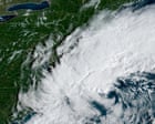
High winds and heavy rain were beginning to batter New England on Friday as a “significant” nor’easter, the first such storm of the fall, threatened to disrupt weekend plans for millions. In the Pacific Ocean, meanwhile, three separate hurricanes, one threatening “catastrophic flooding”, including life-threatening flash floods, in Hawaii, were churning as a record-setting El Niño continued to amplify severe weather events on a global scale. Forecasters said up to 40 million people across multiple US states could be affected by the early season northeasterly storm that was already lashing coastal areas of Rhode Island, Massachusetts, Connecticut and New York’s Long Island by Friday morning.
The online AccuWeather service said winds of 40mph-60mph were expected along the coast from New Jersey to Maine, beginning late Friday, and up to 80mph in and around Montauk, New York. This will bring more rain inland, but more importantly stronger winds closer to shore,” Elizabeth Danco, an AccuWeather expert meteorologist, said in a statement. Up to 8 inches of rain were forecast for some areas of south-eastern Massachusetts, and up to 2 inches in Boston on Friday into Saturday, and the same in New York City a day later.
High wind warnings were in place in Boston and neighboring areas on Friday morning. It also addressed the existence of the nor’easter so early in the season. Nolo was menacing the islands of Hawaii, and expected to be a major category 3 storm as it passes about 80 miles south of Big Island early on Saturday.
Although not forecast to make landfall, Nolo will bring “five days of torrential rain through Monday, catastrophic flooding and mudslides”, AccuWeather’s hurricane experts said. Polo, which intensified rapidly from a tropical storm to a category 5 monster hurricane earlier this week, remained offshore of Mexico on Friday, about 250 miles south-south-west of the Jalisco coast. Its 160mph winds “are likely to cause life-threatening surf, rip currents, and coastal flooding”, in the region, the National Hurricane Center in Miami said.
The storm was forecast to curve around and make landfall somewhere in Baja California on Sunday night or Monday morning as a much-weakened hurricane. Odalys, a category 4 hurricane, was forecast to remain at sea with few to no impacts on land. The El Niño that has contributed to 18 named storms in the Pacific basin this season has had a converse effect in the Atlantic where, for the first time since 1914, no hurricanes formed by 21 September.
Both seasons run until 30 November.
Extract — continue reading at the source.