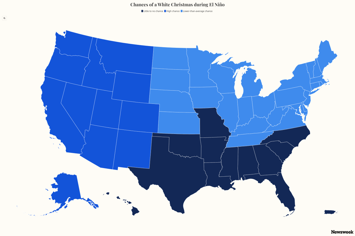
A map showing the historical odds of snow-covered ground on December 25 suggests an El Niño winter could create a stark divide between states where a white Christmas is all but guaranteed in the United States and others where holiday flakes remain a long shot. The National Weather Service (NWS) defines a white Christmas as having at least 1 inch of snow on the ground on Christmas morning. Historical data compiled by the National Centers for Environmental Information (NCEI) show the highest odds are concentrated in northern states, mountainous regions and Alaska, where snowpack is often established well before the holiday.
A white Christmas is far from guaranteed across much of the country. According to the NWS map, probabilities decrease sharply across the South, Gulf Coast and much of the Southeast, where temperatures are typically too warm to sustain snow cover through late December. This year, weather watchers are closely monitoring the potential development of a strong El Niño, a climate pattern characterized by warmer-than-average ocean temperatures in the tropical Pacific.
El Niño can alter jet stream patterns and influence temperature and precipitation across North America during winter. "In a traditional El Niño pattern, the areas that favor a white Christmas are the higher elevations of the western states," AccuWeather meteorologist Peyton Simmers told Newsweek. "December during traditional El Niños is typically warmer than the historical average, yielding a lower-than-historical-average chance for a white Christmas across the eastern United States." A super El Niño is an exceptionally strong version of the natural climate pattern that occurs when sea surface temperatures in the central and eastern tropical Pacific become much warmer than normal, influencing weather patterns around the world.
Strong El Niño events can shift the jet stream, altering winter temperature, precipitation and snowfall patterns across the United States. In its most recent outlook, the NWS Climate Prediction Center said there is a greater than 90 percent chance of a very strong El Niño developing during fall and winter 2026-27 and estimated a 69 percent chance that the event will reach historic intensity, exceeding the strength of previous El Niño events in records dating to 1950. The NWS does not officially use the term "super El Niño," instead describing the event as "very strong." In the United States, El Niño's impacts are usually most noticeable from late fall through winter, with the strongest effects typically occurring between December and February.
While some forecasters have noted the potential for a strong El Niño to develop later this year, the National Weather Service has not yet issued an official winter outlook detailing its expected impacts on U.S. weather and snowfall patterns. Historically, stronger El Niño events often favor a stormier southern tier of the United States while bringing above-average temperatures to parts of the northern U.S. That means some states that normally boast high white Christmas odds could see those chances reduced if warmer air dominates during December.
Even so, several states remain strong bets regardless of broader climate patterns because of their cold climatology and existing snow cover. Alaska stands out as the most reliable white Christmas destination, as do high-elevation regions of western states, such as California, Colorado, Utah, Idaho, Nevada, Wyoming, Montana, Oregon, Washington, and high-elevation parts of Arizona and New Mexico. Meanwhile, northern states like Minnesota and North Dakota might face lower-than-average odds of a white Christmas, as well as eastern states like Maine, Vermont, and New Hampshire, because winter weather behavior is influenced by El Niño.
Extract — continue reading at the source.