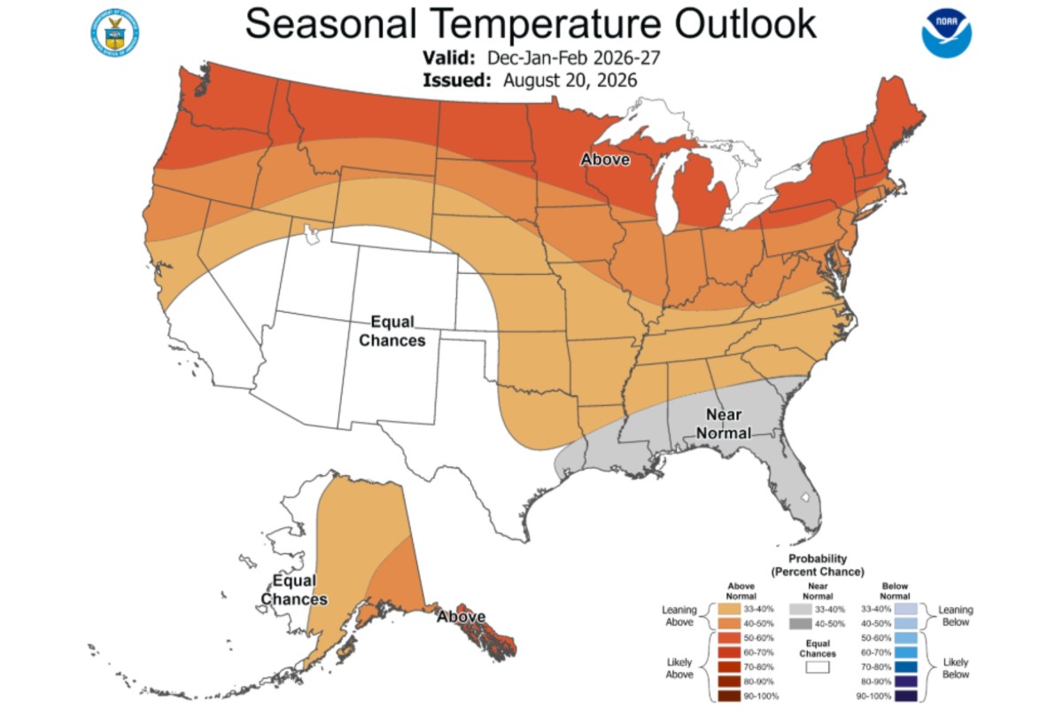
A strengthening El Niño could help shape weather across the United States this winter, potentially contributing to increased chances of precipitation in California and much of the southern U.S. while tilting temperatures warmer across northern states. New maps issued Thursday by the National Oceanic and Atmospheric Administration’s Climate Prediction Center (CPC) show the agency’s temperature and precipitation outlooks for December 2026 through February 2027. The temperature outlook favors above-normal conditions across a broad sweep of the country, from the Pacific Northwest and northern Rockies through the Plains, Midwest and Northeast.
The strongest warm signal appears across parts of the northern tier. Above-normal temperatures are also favored across much of the southern U.S., although the outlook is less decisive in parts of California and the Southwest. A strip along the Gulf Coast, including Florida, has increased chances of near-normal temperatures.
The precipitation map shows that wetter-than-normal conditions are favored from Southern California across the Southwest, southern Plains and Gulf Coast, then through Florida and parts of the East Coast. Drier-than-normal conditions are favored in parts of the Northwest and northern Rockies, with another area centered near the Great Lakes. Large portions of the central and northern US are marked “equal chances,” meaning forecasters do not see a clear tilt toward wetter, drier or near-normal conditions.
ABC7 meteorologist Sandhya Patel highlighted the forecast on X, writing: “WINTER OUTLOOK: From Climate Prediction Center today showing a drastic increase in probability of above normal precip for California Dec-Jan-Feb 2026-27!” The maps do not provide projected temperature readings or rainfall totals. Instead, the colors show where the CPC favors the above-normal, near-normal or below-normal category for the three-month period. El Niño is the warm phase of the El Niño-Southern Oscillation, or ENSO, a natural climate pattern in the tropical Pacific that shifts irregularly every two to seven years.
La Niña is the cool phase of the same pattern. Typically, the phenomenon favors wetter conditions in the southern U.S., including the Gulf Coast and Southeast, while leaving the northern U.S. and Canada warmer and drier than usual. The CPC said on August 13 that El Niño was strengthening and had a greater than 90 percent chance of becoming “very strong” during fall and winter 2026-27.
It assigned a 69 percent chance that the October-to-December season could see a historic event exceeding every previous El Niño’s strength in records dating to 1950. Contact Newsweek editors on this story: John Fitzpatrick and Gray R.
Extract — continue reading at the source.