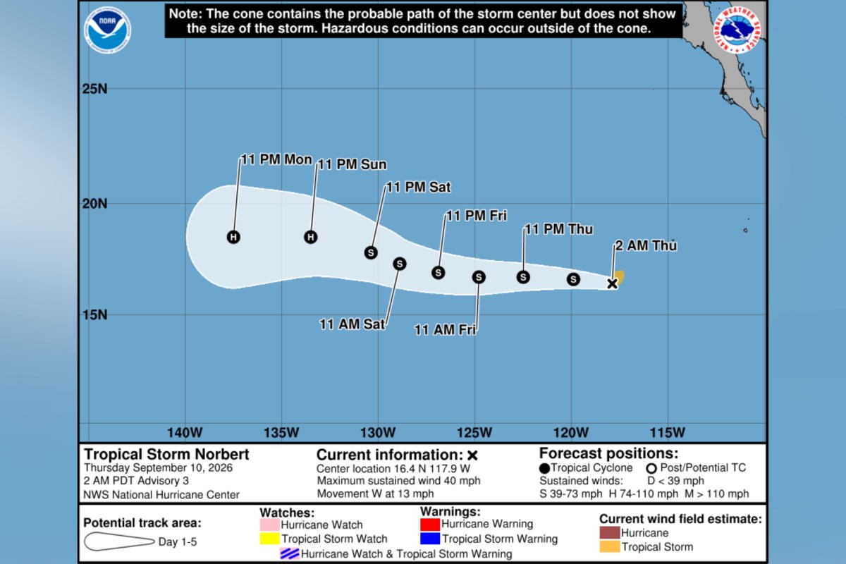
Forecast maps show the possible path of Tropical Storm Norbert after the system became the latest named storm in an active Pacific hurricane season on Thursday. "Norbert has formed early this morning in the Eastern Pacific," Alex DaSilva, lead hurricane expert at private weather company AccuWeather told Newsweek on Thursday morning. "We expect the storm to gradually gain wind intensity as it moves west, becoming a hurricane late this weekend or early next week." In a Thursday morning update, the National Hurricane Center (NHC) said a tropical depression had strengthened into Tropical Storm Norbert.
The system was located around 685 miles southwest of the southern tip of Baja California, moving west at around 13 miles per hour, according to the agency. It reported maximum sustained winds near 40 mph, and said gradual strengthening is expected over the coming days. "There are no coastal watches or warnings in effect," the update said.
"We have a long way to watch this storm as impacts to Hawaii wouldn't be until next weekend at the earliest," DaSilva told Newsweek. "Right now, there is no immediate threat to Hawaii, however residents should monitor the progress of Norbert." The formation of Tropical Storm Norbert marks the 14th named storm in the Eastern Pacific so far this season, according to NHC data. Forecasters previously indicated that the Pacific could see more activity than average this year, thanks in part to the effects of El Niño—a recurring climate pattern known to impact both the Atlantic and Pacific hurricane seasons.
"El Niño conditions are associated with fewer tropical storms and hurricanes, especially in the Western Atlantic Ocean Basin," Matthew Rosencrans, NOAA’s lead for its seasonal hurricane outlook told Newsweek previously. "El Niño conditions are associated with more tropical storm and hurricane activity during the eastern and central Pacific hurricane seasons." Meanwhile, Tropical Storm Lowell was moving westward across the open central Pacific with maximum sustained winds of 65 mph late Wednesday, according to the NHC. HST, its center was about 655 miles northwest of Lihue, Hawaii, and it was traveling west at 13 mph, it said.
The update said gradual weakening was expected, although Lowell is forecast to remain a tropical storm for the next few days. The NHC was also highlighting two areas of the Pacific for potential development as of early Thursday. One was an area of disorganized showers and thunderstorms well south-southeast of the Hawaiian Islands.
Some gradual development is possible late this week and over the weekend as the system moves generally northward before meandering southeast of the islands, according to the NHC. It has a 20 percent chance of formation within 48 hours and a 30 percent chance over seven days. Farther east, an area of low pressure is forecast to form several hundred miles south of the southern tip of the Baja California Peninsula this weekend, the NHC said.
Extract — continue reading at the source.